
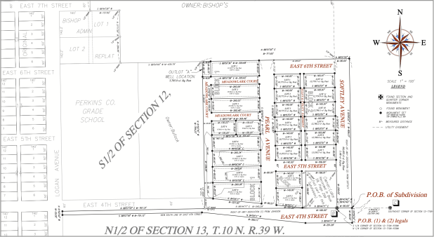
PROPOSED CRA SUBDIVISION — A preliminary plat shows a proposed 23-lot residential subdivision on approximately 15.98 acres east of Perkins County Grade School and north of East Fourth Street in Grant. The Grant Planning Commission and City Council will hold separate public hearings Sept. 9 on a redevelopment plan for the property. The council will also consider rezoning the site from agricultural to residential. City officials emphasized that the map is preliminary and that a final plat has not been completed or approved.
Grant officials to consider new residential subdivision
BY SAMANTHA GOFF
GRANT TRIBUNE-SENTINEL
A proposed new residential subdivision could bring 23 housing lots to nearly 16 acres of currently agricultural land east of Perkins County Grade School in Grant.
The Grant Planning Commission and Grant City Council will hold separate public hearings Wednesday, Sept. 9, concerning the proposed CRA Subdivision. Officials will consider a redevelopment plan for the property, while the City Council is also scheduled to consider rezoning the land from agricultural to residential.
The preliminary plat divides the property into 23 lots spread among three blocks. It also shows extensions or additions to East Fourth, East Fifth and East Sixth streets, along with Pearl and Softley avenues and Meadowlark Court.
The proposed subdivision is located immediately east of Perkins County Grade School and north of East Fourth Street. The preliminary map shows the development extending north toward East Sixth Street, with Softley Avenue forming its eastern edge.
The approximately 15.98-acre property includes portions of Sections 12 and 13 in Township 10 North, Range 39 West.
The plat shows nine lots in Block 1 on the western side of the development, 12 lots in Block 2 on the eastern side and two lots in Block 3 near East Fourth and East Fifth streets.
Lot sizes vary. Several of the western lots are shown at approximately one-half acre, while many of the eastern lots contain approximately one-quarter to one-third acre. Because the document is a preliminary plat, the number, size and arrangement of lots could change before a final plat is submitted and approved.
The first public hearing will be held by the Grant Planning Commission at 5:05 p.m. Sept. 9 in the City Council Chambers at Grant City Hall, 342 Central Ave. The commission will receive comments and review the proposed “Phased Site Specific Redevelopment Plan City of Grant CRA Subdivision 2026.”
The City Council will meet in special session at 7 p.m. that evening. Its public hearing on the redevelopment plan is scheduled for 7:05 p.m.
After the hearing, the council may review and approve the redevelopment plan. It is also scheduled to act on the Planning Commission’s recommendation concerning a request to rezone the property from agricultural to residential.
Although the redevelopment plan and rezoning request involve the same property, they serve different purposes.
Rezoning would change the type of development permitted on the property. The land is currently zoned for agricultural use. Residential zoning would allow the property to be developed for homes, subject to the city’s subdivision, utility, building and other applicable requirements.
The redevelopment plan establishes how the site could be developed under Nebraska’s Community Development Law. The term “phased” indicates that the subdivision could be constructed in stages rather than all at once. The hearing notices do not specify when construction would begin, which lots would be included in each phase or how quickly the entire development might be completed.
The notices also reference a cost-benefit analysis required under Nebraska law. Such an analysis is required when a redevelopment plan proposes using tax-increment financing, commonly known as TIF.
Under TIF, the property’s existing taxable value generally remains available to the local taxing entities. As development increases the property’s value, some or all of the new property tax revenue generated by that increase may be used to pay eligible redevelopment expenses, such as streets, utilities or other infrastructure.
The city’s cost-benefit analysis is intended to examine the potential effects of that financing arrangement on the city, school district, county and other taxing entities, as well as the anticipated economic and public-service effects of the project.
Unknown at this time are the precise infrastructure costs, construction schedule or financing amount. Those details may be contained in the redevelopment plan and cost-benefit analysis available at City Hall.
Two additional areas are identified for proposed street right-of-way. One consists of approximately 1.44 acres along East Fourth Street, and the other includes approximately 1.48 acres along Softley Avenue. Right-of-way dedication reserves land for public streets and associated infrastructure.
Approval of the redevelopment plan and rezoning would represent important early steps for the project, but it would not make the preliminary plat final. City Clerk Jessie Faber said the map provided for the hearings is preliminary because the final plat has not yet been completed or approved.
A final plat would establish the subdivision’s official lots, blocks, streets, easements and other boundaries. It would still need to complete the city’s applicable review and approval process before being recorded.
Members of the public may comment during either redevelopment-plan hearing. The council’s special meeting begins at 7 p.m. Both meetings will be held in the City Council Chambers.
Copies of the redevelopment plan, cost-benefit analysis and property map are available for public inspection at the city clerk’s office in City Hall.